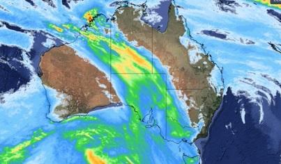
A massive weather system spanning 4,000km is expected to rain on 80 percent of Australia as it moves from the west to the east coast.
Pools of cold, unstable air from the northwest, fueled by tropical moisture, should bring falls to every state and territory over the next week, Weatherzone says.
The dynamic cold front and rain band stretching from the Kimberley through the Central Outback to the Murray-Darling Basin could also produce thunderstorms, hail and snow.
Wet and stormy weather will be mainly felt in Western Australia before spreading across central and southern Australia from Thursday and eastern Australia from Friday, the Bureau of Meteorology said.
“The band of rain is expected to continue tracking eastward into eastern parts of South Australia, Victoria, Tasmania and southwestern parts of Queensland in the Northern Territory,” meteorologist Sarah Scully said.
Thunderstorms are possible, with the potential for widespread precipitation totals of five to 15 mm and isolated totals of up to 50 mm.
“It's going to be wet and windy tomorrow in the south-east quadrant of the country,” Ms Scully said.
“It could (also) be a wet weekend for eastern parts of NSW with areas of rain and possible widespread showers.”
Damaging winds are expected in higher parts of Victoria and the exposed south coast and eastern parts of Tasmania on Thursday.
Heavy rainfall is possible in north-east Victoria late on Thursday, with a total of 50 to 70 mm of rainfall possible every six hours.
“These could lead to flash flooding,” Ms Scully said.
A second rain-bearing system is expected to bring follow-on rain to parts of WA from Saturday or Sunday.
Nationwide soaking waters were blocked throughout the summer months by a persistent high-pressure ridge entrenched in the south of the country.
That blocking high-pressure pattern was finally broken this week, creating the first northwest cloud band of the season, with significant rain expected in every state and territory.
The heaviest falls are expected in South Australia and WA, with moderate rain likely in parts of Tasmania.
Heavy rainfall in NSW is also possible due to the interaction between the northwest cloud band and a developing low pressure trough in the Tasman Sea.
Severe storms with destructive winds and hail have brought much-needed rainfall to drought-hit farmers in WA's Wheatbelt.
The heaviest falls occurred in the Bunbury area, with 72mm falling in the 24 hours to 9am on Wednesday morning.
Bridgetown received 18mm of rain, Katanning 12mm, Brookton 20mm and Corrigon 10mm.
“This is the rain that Wheatbelt farmers have been waiting for,” said meteorologist Jessica Lingard.
Perth was also hit by thunderstorms, with 26mm of rain recorded in the 24 hours to 9am.
Trees and power lines were downed as some suburbs were hit by significant hail.
